
Performance
About
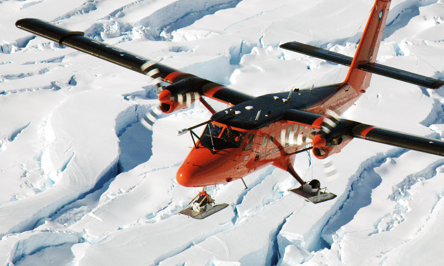
Four aircraft of the DHC 6 300 series with STOL capabilities. They can operate from paved and unpaved surfaces. All four can undertake polar logistics support including to sea-ice camps. They can be equipped with wheel skis and have extended range tanks fitted. Two aircraft are modified to support airborne and remote sensing applications.
The type of science supported
The aircraft have supported research monitoring and recording interactions between the Earth’s crust, ice- and snow-covered areas, oceans and the atmosphere. This is both from a logistics perspective in deploying instruments and field camps but also as airborne research platforms
- Mapping of the Earth’s magnetic and gravity field, ice thickness & structure, sea ice thickness, snow thickness on sea ice, surface morphology/altimetry
- Measuring in-situ and remotely aerosols and trace gases
- Measuring temperatures, humidity, wind distribution
- Radiation measurements
- Optical remote sensing
GPS Positioning
Two GPS logging at 2Hz and 10Hz are used. This provides a true dual redundant system utilising two dissimilar GPS receivers, mitigating against drop-outs due to firmware coding errors. A Leica GPS 500 provides the primary GPS and a Novatel DL-V3 provides the system redundancy.
GPS NMEA and 1pps distribution
GPS NMEA and one pulse per second (1pps) are distributed to all systems to provide synchronisation of all the data and formation of coherent data sets.
Inertial Measurement Unit (IMU)
Aircraft attitude and inertial information is provided by an IMAR FSAS inertial unit (being a non-ITAR controlled system it can be more readily used in foreign countries). The IMU data is logged to a Novatel Span receiver.
Magnetometer
Sintrex CS3 sensors are used due to their high sensitivity, high cycling rates, excellent gradient tolerance, fast response and low susceptibility to the electromagnetic interference.
AGIS (Airborne Geophysical Information System)
The AGIS data-logging system is used to log the magnetometer data at a frequency of 10Hz with a sensitivity of 1 pico Tesla, radar altimeter data and fluxgate magnetometer is also logged. AGIS also provides pilot guidance information.
Radar Altimeters
Data are recorded from the aircraft's radar altimeter fitted in the tail section at 10Hz. These have a range of around 800-1000m and a wider beam compared to the laser altimeter.
Fluxgate Magnetometer
A Billingsley TFM100G2 fluxgate magnetometer is mounted in the tail of the aircraft. This provides corrections for magnetometer data.
Laser Altimeter
A Riegl LD90-3800VHS-FLP Laser Altimeter is fitted in the floor camera hatch. Returns up to 700m over snow are possible depending on the surface reflections. A repetition frequencies up to 2kHz can be achieved giving an along-track measurement every 3cm with an accuracy up to 5cm.
LiDAR
A Riegl LMS-Q240i provides a near-infrared solution for ice research in Polar Regions for ranges up to 650m at 2cm accuracies. An Optech ALTM 3100EA* or Leica ALS50 provides an infrared-based solution suitable for high altitude (1km nominal) wide area (5000+ km2) surveys at 5cm accuracies.
Ice Penetrating Radar
The ice-penetrating radar is a coherent two pulse radar with an output of 4KW radar at 150MHz. The radar is capable of imaging ice to depths of 5km with an along track resolution of 10cm before processing and a depth resolution of 8m.
Gravimeter
Aero gravity measurements are acquired with a modified LaCoste and Romberg air/sea gravimeter. Crossover analysis indicates the free-anomaly field is accurate to ~5mGals for wavelengths greater than 10km. A Chekan* airborne gravimeter has also been flown in Antarctica. Various IMAR strap down gravity systems have also been flown.
AHRS
A secondary aircraft attitude reference is available from the aircrafts Litef LCR92 attitude and heading reference system.
VGA and HD video cameras
A solid state standard or HD Sony video camera can be installed to provide forward looking or downward looking video. This provides standard or high definition video and a forward view for the operator when located in the cabin. These can be time stamped or overlaid with GPS position.
Canon 7D
A downward pointing DSLR in the camera bay provides synchronised high resolution surface imagery.
ASIRAS
ASIRAS is an airborne SAR-altimeter instrument owned by ESA.
ASIRAS is essentially a Ku-band altimeter but with a high pulse repetition frequency such that it is phase sensitive and pulse-coherent. The carrier frequency of the radar is 13.5 GHz and the bandwidth is 1 GHz. It returns information on surface snow including over sea ice.
POLARIS
POLARIS is a large antenna enclosure capable of housing a variety of antenna arrays. The current configuration houses four 150MHZ antennas to be used with the PASIN radar system.
Polardex assistant
Sign in to ask about polar stations, vessels, aircraft and planned expeditions.
Sign in